1/3
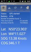
Mad Mutt Marine GPS Navigator screenshot 0
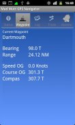
Mad Mutt Marine GPS Navigator screenshot 1
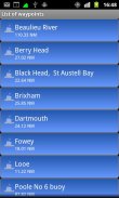
Mad Mutt Marine GPS Navigator screenshot 2
Mad Mutt Marine GPS Navigator Icon

Mad Mutt Marine GPS Navigator

University of Plymouth Enterprise Ltd
Trustable Ranking IconVertrauenswürdig
1K+Downloads
273kBGröße
Android Version Icon2.2.x+
Android-Version
1.07(04-08-2014)Letzte Version
3.0
(1 Bewertungen)
Age ratingPEGI-12
Herunterladen
DetailsBewertungenVersionenInfo
1/3

Beschreibung von Mad Mutt Marine GPS Navigator

I started writing this application as something that would be useful to me. Since that it has grown and I am rather pleased with it. It is an aid to marine navigation and must be used in conjunction with charts that are printed on that white stuff that is called (So I’m told) paper.


Features


•Designed by and for a sailor. You may find that some of the layouts look “big and blobby” at first sight, but they work at sea. Fiddly and fussy layouts do not.


•No network required. This app uses your phone’s GPS, it will work where there is no mobile network coverage (though you will need network coverage to share your logs and waypoints by email).


•Store unlimited waypoints (restricted in free version).


•View waypoints alphabetically of by distance from your current position.


•Display range and bearing to a waypoint.


•Make logs of where you have been, which you can annotate with comments and other relevant data.


•View logs as display on the phone.


•Share logs with Google Earth on your phone or desktop computer, either by email or by copying KML files.


•Share waypoints with Google Earth on your phone or desktop computer, either by email or by copying KML files.


•Share logs with Google Earth on your phone or desktop computer, either by email or by copying KML files. Although I don’t encourage the use of Google Earth for marine navigation, seeing your waypoints on Google Earth is a useful visual check that you have transcribed them correctly.


•Anchor watch alarm service. Alerts you if you have moved more than a pre-defined distance. The anchor watch also alerts you if the battery level is low.


•Near waypoint alarm service


•Once started, the log, anchor and waypoint alarm services will continue to run, even if you quit the main navigator application. They will continue to run while you make phone calls or use your phone for email, Internet browsing or pretty much anything else.


What this application is not


It is not a chart plotter. This application is intended for marine navigation. Although it could be used by ramblers, that isn’t the main intention. It does not display digitised charts, nor does it show you a Google Map view with your position displayed on it. I believe it is highly irresponsible to encourage the use of Google maps to navigate boats. Even in rivers and estuaries, Google maps contain no semantics for the sea whatsoever; no lights and marks, depths, rocks etc. The application does allow you to send logs you have made to Google Maps, though, but only after you have completed the trip.


Free Version


For a limited time, a free version is available. In the Autumn of 2012 a full feature version should be available.


The free version has the following limitations:


•The number of waypoints you can have is restricted to 20.


•Routes are not availableIch begann diese Anwendung als etwas, das nützlich für mich sein würde. Seit dem ist es gewachsen und ich bin ziemlich zufrieden mit ihm. Es ist eine Hilfe zur Navigation auf See und ist in Verbindung mit Charts, die auf diesem weißen Zeug, das heißt (also ich habe gehört) Papier gedruckt sind, verwendet werden.


Eigenschaften


• Entwickelt von und für einen Matrosen. Sie können feststellen, dass einige der Layouts aussehen "großen und Blobby" auf den ersten Blick, aber sie auf See zu arbeiten. Fummelig und kleinlich Layouts nicht.


• Kein Netzwerk erforderlich. Diese App nutzt GPS des Telefons, wird es funktionieren, wo es keinen Handy-Netzabdeckung (auch wenn Sie die Netzabdeckung benötigen, um Ihre Protokolle und Wegpunkte mit anderen zu).


• Lagern Sie unbegrenzte Wegpunkte (in der kostenlosen Version beschränkt).


• Anzeige der Wegpunkte alphabetisch nach Entfernung von Ihrer aktuellen Position.


• Anzeigebereich und das Lager zu einem Wegpunkt.


• Stellen Sie Protokolle von wo Sie gewesen sind, die Sie mit Kommentaren und anderen relevanten Daten mit Anmerkungen versehen können.


• Anzeigen von Protokollen, wie die Anzeige auf dem Handy.


• Teilen Logs mit Google Earth auf Ihrem Handy oder Desktop-Computer, entweder per E-Mail oder durch Kopieren KML-Dateien.


• Teilen Wegpunkte mit Google Earth auf Ihrem Handy oder Desktop-Computer, entweder per E-Mail oder durch Kopieren KML-Dateien.


• Teilen Logs mit Google Earth auf Ihrem Handy oder Desktop-Computer, entweder per E-Mail oder durch Kopieren KML-Dateien. Obwohl ich nicht fördern den Einsatz von Google Earth für Schiffsnavigation, sehen Sie Ihre Wegpunkte auf Google Earth ist eine nützliche visuelle Kontrolle, dass Sie sie richtig transkribiert haben.


• Anker-Uhr Alarm Service. Warnt Sie, wenn Sie mehr als eine vordefinierte Strecke bewegt haben. Die Ankerwache warnt Sie auch, wenn die Batterie schwach ist.


• In der Nähe Wegpunkt Alarm-Service


• Einmal gestartet, wird das Protokoll, Anker-und Wegpunkt Alarm Dienste laufen weiter, auch wenn Sie den Hauptnavigations Anwendung zu beenden. Sie werden weiterhin laufen, während Sie telefonieren oder nutzen Sie Ihr Handy für E-Mail, Surfen im Internet oder so ziemlich alles andere.


Was ist diese Anwendung nicht


Es ist nicht ein Kartenplotter. Diese Anwendung ist für marine Navigation geeignet. Obwohl es von Wanderern genutzt werden könnte, ist, dass nicht das Hauptziel. Es ist nicht digitalisiert Diagramme anzeigen, noch zeigen Ihnen eine Google Map-Ansicht mit Ihrer Position auf diese angezeigt. Ich glaube, es ist höchst unverantwortlich, die Verwendung von Google Maps zu ermutigen, Boote navigieren. Auch in Flüssen und Flussmündungen, Google Maps enthalten keine Semantik für das Meer überhaupt; keine Lichter und Marken, tiefen, Felsen usw. Die Anwendung muss Zugriff auf Protokolle Sie Google Maps, aber, aber nur, wenn Sie die Reise abgeschlossen haben, gemacht haben zu senden.


Free Version


Für eine begrenzte Zeit, ist eine kostenlose Version zur Verfügung. Im Herbst 2012 sollte eine vollständige Feature-Version verfügbar sein.


Die kostenlose Version hat folgende Einschränkungen:


• Die Anzahl der Wegpunkte man haben kann ist auf 20 beschränkt.


• Routen sind nicht verfügbar

Mad Mutt Marine GPS Navigator – Version 1.07

(04-08-2014)
Weitere Versionen
Was ist neuThis app isn't supported (much) any more; it is a taster for the full version.An "add today's date" to the log file name button has been added.Also, the free version now allows more waypoints (40)If I have broken anything in the process of fixing niggles, do let me know.

Es gibt noch keine Bewertungen oder Beurteilungen! Um die erste zu hinterlassen, installiere bitte

-
1 Reviews
5
4
3
2
1
Info Trust Icon
Garantiert gute AppDiese App hat die Sicherheitstests gegen Viren, Malware und andere Schadattacken bestanden und enthält keine Bedrohungen.

Mad Mutt Marine GPS Navigator – APK Informationen

APK Version: 1.07Paket: uk.ac.plymouth.madmutt.gpsnavigator
Kompatibilität zu Android: 2.2.x+ (Froyo)
Entwickler:University of Plymouth Enterprise LtdDatenschutzrichtlinie:https://sites.google.com/site/madmuttsoftware/privacy-policyBerechtigungen:3
Name: Mad Mutt Marine GPS NavigatorGröße: 273 kBDownloads: 727Version : 1.07Erscheinungsdatum: 2020-05-18 09:26:10Min. Bildschirmgröße: SMALLUnterstützte CPU:
Paket-ID: uk.ac.plymouth.madmutt.gpsnavigatorSHA1 Signatur: 34:11:26:83:9C:8D:FF:92:D9:66:6F:2D:86:F0:3E:0F:D6:F2:53:47Entwickler (CN): Nigel BarlowOrganisation (O): Plymouth UniversityOrt (L): PlymouthLand (C): UKBundesland/Stadt (ST): Devon

Neueste Version von Mad Mutt Marine GPS Navigator

1.07Trust Icon Versions
4/8/2014
727 Downloads273 kB Größe
Herunterladen

Weitere Versionen

1.06Trust Icon Versions
24/7/2013
727 Downloads273 kB Größe
Herunterladen
appcoins-gift
AppCoins GamesGewinne noch mehr Belohnungen!
mehr
Eternal Evolution
Eternal Evolution icon
Herunterladen
Bed Wars
Bed Wars icon
Herunterladen
March of Nations
March of Nations icon
Herunterladen
Mobile Legends: Bang Bang
Mobile Legends: Bang Bang icon
Herunterladen
Game of Sultans
Game of Sultans icon
Herunterladen
Bus Simulator : Ultimate
Bus Simulator : Ultimate icon
Herunterladen